Strategic Land Asset – Technical Profile
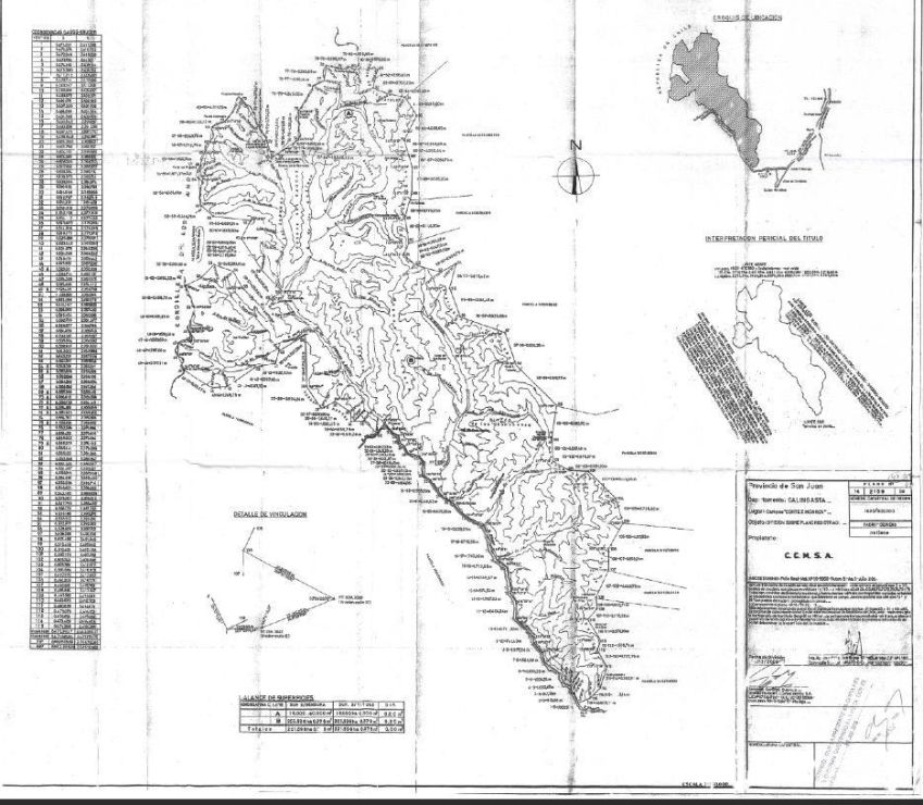
Surface Area
203,598 continuous hectares.
Location
San Juan Province, Argentina. Calingasta Department. Andes Cordillera region, bordering Chile.
Geographic Coordinates
31°–32° South latitude, 70° West longitude.
Altitude
High-mountain territory exceeding 5,000 meters above sea level, with peaks near 6,200 meters within the Ansilta mountain system.
Geography and Terrain
High Andes landscape including mountain ranges, broad valleys, deep ravines, pedemont areas, natural grasslands, rivers, lagoons and plateaus.
Climate
Continental semi-arid mountain climate with cold winters, warm summers, high solar radiation, low humidity, strong thermal amplitude and seasonal snow cover lasting up to seven months at higher elevations.
Hydrological Resources
One of the most significant water systems in San Juan Province, with permanent rivers, snowmelt-fed streams, lagoons, glaciers and year-round springs originating within the property.
White River Basin
The asset includes a substantial portion of the Río Blanco basin, formed by the Santa Cruz and Salinas rivers. Río Blanco feeds Río Los Patos, which in turn supplies the San Juan River, the backbone of provincial irrigation.
Glaciers and Snowfields
Active high-altitude glaciers and snowfields such as Schiller Glacier and La Fría snowfield ensure long-term water regulation, even during extreme drought cycles.
Thermal Springs
Naturally occurring thermal springs averaging 24°C, including sulfurous waters traditionally used for therapeutic purposes.
Water Legal Framework
Provincial law recognizes ownership of water originating within the property, enabling productive, energy and supply-related development.
Energy Potential
Hydroelectric potential from permanent flows and elevation gradients; high solar irradiation suitable for large-scale solar evaluation; natural wind corridors suitable for future wind energy studies.
Mining Potential
Located in a high-priority geological zone with regional exploration history and proximity to active mining districts in Argentina and Chile.
Identified Minerals
Gold, silver, copper, molybdenum, iron, lead, zinc, gypsum (alabaster), kaolin, aragonite, marble, lapis lazuli, aluminum, sodium, magnesium and manganese sulfates.
Critical Minerals
Integrated potential for rare earth elements and strategic minerals aligned with global energy transition and advanced technology demand.
Livestock
Active extensive grazing system supporting up to 50,000 head simultaneously, with annual circulation exceeding 200,000 animals. Predominantly caprine (70%), followed by ovine (20%) and other species (10%).
Camelids
Presence and development potential for llamas, vicuñas, guanacos and alpacas for fiber, meat, logistics and eco-tourism.
Agriculture and Forestry
Valleys suitable for selective agriculture, improved pastures and controlled forestry including conifers and cypress species.
Viticulture
Favorable conditions for premium high-altitude viticulture, particularly Syrah, supported by solar exposure, thermal amplitude, mountain soils and water availability.
Tourism
Year-round tourism potential including adventure tourism, fly fishing, mountaineering, rafting, thermal tourism, nature tourism and winter snow activities including ski center evaluation.
Access and Connectivity
More than 65 natural mountain passes to Chile, including low-altitude corridors such as Paso La Paloma (~3,600 masl), enhancing strategic regional connectivity.
Documentation
Title deeds, water analyses, water code documentation, technical studies, photographic records and supporting professional reports available for due diligence.
Positioning
A large-scale strategic land asset integrating real land, water, minerals, energy, production and conservation, designed for long-term investment and flexible development strategies.